
It was a lovely summer morning when the ferry, the MV Salish, sailed from Coupeville. I sat by the window and pulled out the Chetzamoka Trail brochure. Though I’ve visited Port Townsend dozens of times, today was different. The brochure mapped out a 3 mile, 6 mile and 12 mile route for walking, biking or driving with 18 sites important to the S’Klallam people. Checking the tides, I studied my options and decided to take the big loop in a sunwise direction
Stepping off the ferry, I could see the historic post office overlooking the waterfront. I turned right, then left, climbed some stairs and took the sidewalk up the street. The trail sign across from the building told about the Boldt Decision of 1974 that assured native rights to fish in their “usual and accustomed places”. The sign in front of the post office told of chief Chetzemoka and his family whose images were carved in stone above the door. How many times had I passed this building without noticing that?
I walked by the Jefferson County Courthouse, a red brick monolith a few blocks away, then strolled through uptown admiring the homes and gardens in this historic district. Crossing the street near the Food Co-op I passed Kah Tai Lagoon where I found dog walkers and birdwatchers. Cedar Waxwings flitted among the trees. It was a verdant path, historically, a good hunting ground for waterfowl. The trail led by the bus terminal next to Safeway and I remembered that Jefferson County buses were now free, just like on Whidbey, another option if I got too tired. I continued my walk reassured by occasional trail logos embedded in the sidewalk.
Walking around the edge of the golf course, I spied antlers branching up from the tall grass where two deer rested in the shade. I climbed the hill to the YMCA and sat under a tree having a snack while watching an enthusiastic game of pickle ball with the Olympics in the distance. Across the street is the golf course clubhouse next to a camas prairie where a statue of Chetzamoka waves to signal a peaceful transition.
From there I turned toward the High School and walked by a beautiful mural. Turning down F Street then right by Quimper Village, I took a bike path toward the Middle School. Following the map, I turned north and walked by the County Fairgrounds where I heard lively music from the campground and was reminded that it’s time for Fiddle Tunes. I walked on until I reached North Beach and stopped for lunch at a picnic table. Sailboats tilted with the wind, people explored the exposed shoreline. This was a favorite camping spot for natives arriving by canoe.
Walking into Fort Worden State Park, I turned to see the lake below and the distant mountains before following the bluff trail eastward. Fort Worden was built in the 1890’s along with Fort Casey and Fort Flagler to guard the entrance of Puget Sound. I passed gun emplacements along the trail and stopped to read the poems at the Memory Vault. I walked down by the soldiers’ quarters, before turning toward the wharf. After getting an ice cream at the Canteen, I stepped onto the beach, took off my shoes, rolled up my jeans and walked in the shallows for a mile enjoying the cool water on this hot day. I passed by the stairs at Chetzamoka Park and walked on to Point Hudson.
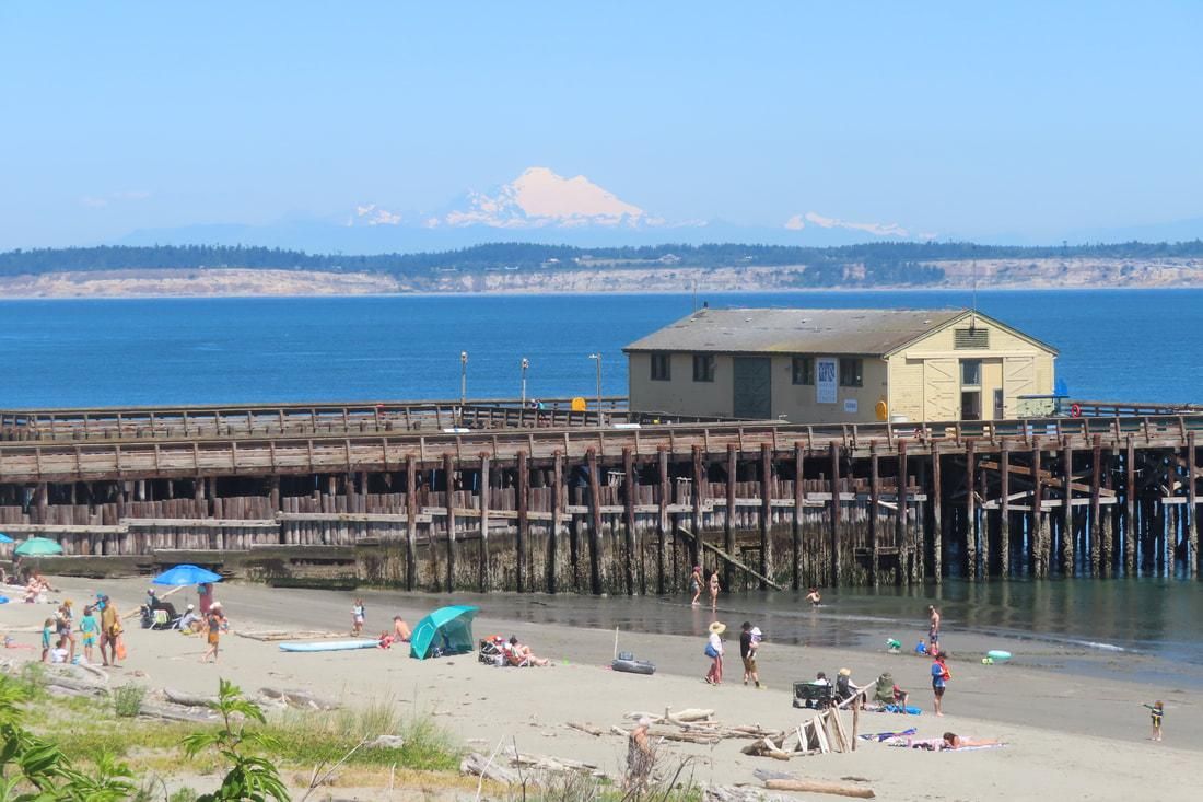
photo: Fort Worden wharf.
At the RV Park, I brushed the sand off my feet and put my shoes back on while imagining the Indian camp that was once on this site, a good place for clamming. Walking around the marina to the Northwest Maritime Center I read about the canoe culture. The totem pole outside was where I’d picked up this trail brochure months ago. Pulled along by the festive flow of tourists on Water Street I stopped to see the whale skeleton suspended at the dock.
As I boarded the ferry for home, I reflected on the stories of the S’Klallam posted on each trail sign I'd passed. Chetzamoka led his people through a difficult transition. White settlers owe a great debt to his peaceful leadership ability.
PS Avoid the ferry lines by leaving the car behind. Walk on the boat and pick the route that suits your time and abilities. Whether you bike it or hike it, I encourage you to stop and read the signs posted at the historic sites. It will broaden your perspective on the Port Townsend we know and love.
This trail is a partnership between the Native Connections Action Group, the Quimper Unitarian Universalist Fellowship, and the Jamestown S’Klallam Tribe with support from local sponsors. You may get a copy of the trail brochure at the Northwest Maritime Center on the north end of Water Street or click here for a map
Directions
Directions: Take the Coupeville Ferry to Port Townsend and follow the trail map on the route you choose. If you start from the NW Maritime Center at the north end of Water Street (where you can get a map), the 3 mile loop will lead you to the post office, toward the high school, to Chetzamoka Park and back to the NW Maritime Center. The 6 mile loop will add a walk along Kah Tai Lagoon and back by the golf course. I described my walk on the 12 mile loop that can also be done by bike.
By Bus and Bike: Port Townsend is a bike friendly town, speed limits are slow, but Water Street is very busy so wear something bright and use lights. The Jefferson Transit buses are free with service Monday-Saturday. See their schedule here. Routes 2, 3 and 11 serve stops along the trail. Call 360-385-4777 or 800-371-0497 to talk to a real live person.
Trail Conditions: Mostly sidewalks or grassy shoulders, with gravel or dirt trails in some places on a mostly gentle grade. There is a hill between Water Street and the residential area uptown. Restrooms and refreshments are available in town but bring water and snacks for the longer walk or bike ride.
Republished with permission. Read the original article.