
Oh, the mighty Skagit River. It scours the mountains and sweeps the valley flats, bringing sand and tree trunks to the Salish Sea. After reaching Skagit Bay, winter’s southerly storm winds drive the waters northward, eroding glacial till from the steep island bluffs. This conveyor belt delivers its load of logs and silt to drop-off points such as Ala Spit.
In the 1960s, a homeowner built a retaining wall south of Ala Spit, causing the beach to thin out, leading to the loss of nearshore habitat and spawning areas, and damaging the pocket estuary behind it. The neck of the spit narrowed to where it would soon be all gone.
Island County used the Conservation Futures program to purchase the spit for a county park. A few years later, they obtained funding to study solutions to the erosion and do something about it. They removed the riprap and bulkhead and replaced the driftwood and sand.
Since then, the neck has fattened up again. Ala Spit again supports spawning forage fish, shellfish, driftwood, and dreams.
Kath and I visited there during a king-tide storm last December. Waves out of the south crashed on the base of the spit; driftwood danced and shifted under our feet; new logs shipwrecked themselves on the windward side. We tried getting to the far northern point, but we would have had to swim – the spit had been split in two.
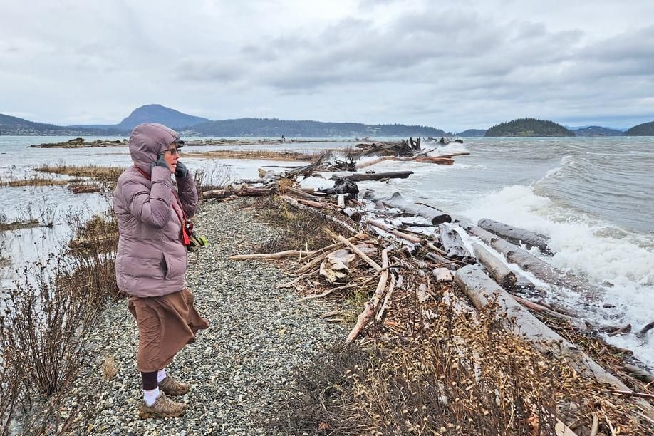
Ala Spit in December 2024 during a King Tide storm
Ala Spit in December 2024 during a King Tide stormWe returned there this week. The only evidence of that storm was the large woody debris still burying Ala Spit, adding to its strength to resist future storms. This day was flat calm. The air hung heavy, misty, veiled, peaceful, fully at rest. Hope and Skagit islands lay shrouded in fog; Goat Island to the south appeared as an apparition on the horizon. The sea lay like a comforter, deep silver draped against the shore. All was gray, all was quiet.
We walked along the pocket estuary as the tide fell away. The shoreline along here is thick gooey mud. Footprints half a foot deep showed where a previous hiker had strayed too close. At the northern end, the mud becomes sand, then a mix of sand and gravel – glacial till. A piper flittered and fluttered along the wrack line, finding tidbits to nibble. Two hikers greeted us with their dog Ziggy. Our dogs sniffed and ran and played together, then Murphy had enough and the hikers continued on ahead. As we rounded the corner, a passing boat threw out a wake to crash on the beach, then subside, then disappear as if it had never happened.
Kath explored a tiny sub-spit pointed out toward Hope Island. She found a micro-tidepool with tiny green anemone babies, no larger than a pencil eraser, getting started in their beach life. I stood at the end of the point and watched the tide withdraw. A fist-sized stone lay just under the water’s surface. I could see the sea level dropping down the side of the rock, and within minutes the stone was high and dry.
I stood there and listened. A seagull chatted a plaintive word across the water, then swam quietly, contentedly. Barnacles gently closed their doors waiting for the sea to return. The floating mist muted all else. Life, sounds, and seemingly the entire world had all ebbed away.
We walked to the south end of Ala Spit, where the riprap and bulkhead no longer interfere with the life of the beach. We looked back at the length of the peninsula, seeing the magnificence of a living beach like this, holding its own in the dynamic world of the Salish Sea, in the unknown world of the future.
On days like this, the waves whisper secrets and the sand plays host to sea life, land life, the lost, the lonely, the lovers and dreamers alike.
Directions
Trail conditions: The 'trail' is a beach on each side, and a grassy/gravelly/loggy path down the middle. The west side is muddy at low tide, sandy higher up. The east side is mostly gravel except at the pinch point there is a valley of muddy sand.
Directions: Take Troxell Road east from Highway 20 at the north end of Whidbey Island. Follow it as it winds around to the east side of Whidbey until you arrive at Geck Road on your left, the access to Ala Spit County Park.
By Bike: Troxell Road is a low-traffic but high speed road, hilly with a narrow shoulder.
Mobility: The parking area is gravel and mud, but right on the beach. The trail is described above, with some scrambling over logs required in places.
Republished with permission. Read the original article.